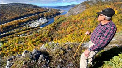
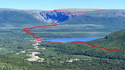
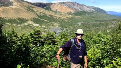
On October 15, octogenarian Arne Helgeland hiked up 335 meters (1100 feet) to Arne’s Lookout at the top of the new IATNL Bear Head Trail. Follow along as he takes in the bright fall colours and fantastic views of the lower Humber Valley.
On Friday, June 25, after 2.5 years of intermittent work, the International Appalachian Trail Newfoundland & Labrador (IATNL) launched the Elephant Trail on the south side of Trout River Pond with a group hike of 14 people. The trail is at the northern end of the 3-day North Arm Traverse, with the southern end located at the IATNL Basecamp at Stowbridges on the north side of North Arm, Bay of Islands.
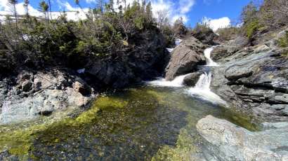
With early spring in the lowlands and late winter in the highlands, IATNL/Cabox Chairperson Paul Wylezol set off to cross the eastern end of Blow Me Down Ophiolite Massif to check out a series of waterfalls on Knights Brook, where the crystal-clear stream emerges from the mountains and turns south to follow its course through 7kms of foothills to the eastern end of Serpentine Lake. In 2021 spring arrived a month early in Western Newfoundland, which permitted this April 25 trek. Temperatures ranged from 8 to 10C at the base of the mountains and in the valleys, but hovered between 2 and 4C on top, where a 20-30km breeze across large swaths of snowpack added a ‘still winter’ chill.
On April 14 during the mildest spring in many years, IATNL Directors Paul Wylezol and Delano Pittman took advantage of a blue sky day to make the first spring trek of the new IATNL/Cabox Geopark Elephant Trail on the south side of Trout River Pond, which will be completed to the top of the Elephant’s back by early Summer 2021. The 10-hour 23-kilometer trek began approximately 2kms past Trout River Campground on Chimney Cove gravel access road, where an ATV trail makes a right angle intersection and follows the Gros Morne National Park boundary southeast to within 1 kilometer of the foot of the Elephant.
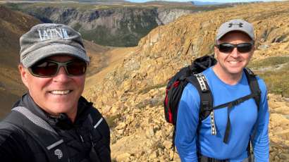
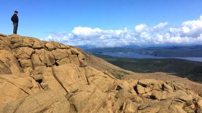
On September 16, IATNL directors Paul Wylezol and Delano Pittman set off from Benoit’s Cove on a trek across the Blow Me Down Mountains to fine tune some Cabox Geopark hiking routes and identify points of interest. After a 3km drive up Webcon forestry access road, then a ford of Clark’s Brook, Paul and Delano scrambled up over a peridotite scree field on their way to the top of the mountains. Once on top, the landscape changes considerably to low rolling serpentine barrens with occasional patches of low grass and puddle strewn wetlands.
As one of the most spectacular and remote canyons on the island of Newfoundland, Simms Gulch on the south side of the Blow Me Down Mountains requires inclusion on any diehard adventurer’s bucket list. Located above the northwest corner of Serpentine Lake, it is accessed by gravel logging road after a 1.5 hour drive from either the Trans Canada Highway or town of Mount Moriah on the south side of the Bay of Islands. In the 1960s this pristine wilderness area, along with the northeast corner of the Lewis Hills, was held in reserve for a major provincial park. However with the designation of Gros Morne National Park surrounding nearby Bonne Bay, the plan was abandoned and the
On August 17 after an unusually long dry spell in Western Newfoundland, IATNL/CABOX Director Paul Wylezol set off from the Lewis Hills Trail’s northern trailhead in search of a hiking route to the east rim of Wheelers Gulch on the northeast corner of the Lewis Hills, then returned via the relatively dry Blue Hill Brook that flows north along the base of the mountains into the western end of Serpentine Lake near its outflow into Serpentine River. After walking the trail up through the forest and above the tree line at the base of the “hills”, Paul turned left (south) and scrambled up over rock and low scrub as he followed the course of a small stream that marks the boundary between …
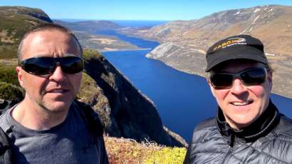
Though it was a little warm for hiking, the occasional cloud and ocean breeze made for a pleasant 12-hour 23km trek into the remote western Blow Me Down Mountains on August 11. The goal was to find an access to/from the mountains below Round Hill and The Haystacks (the highest peaks on the Blow Me Downs) that would provide a 2-day east-west traverse of the hills from Benoit’s Cove via Simms Gulch. The route requires a small amount of bushwhacking and a little scree hopping, but with a few improvements will provide an intermediate level trek with great new views and more stunning geology.
On the morning of July 23, IATNL directors Paul Wylezol and Delano Pittman set off in pickup truck down a gravel road just south of Trout River, heading to the remote resettled community of Chimney Cove on the gulf coast about midway between Trout River and the Bay of Islands. They were on a mission to find a hikeable route to the top of Mount St Gregory from Chimney Cove that would serve as the northern leg of a planned ST GREGORY’S CROSS one-day trek from Lower Crabb’s Brook on the north shore of the Bay of Islands to Chimney Cove, then on to Trout River at the edge of Gros Morne National Park.
On May 21, IATNL Directors Paul Wylezol and Delano Pittman took advantage of a beautiful day during an ideal time of year to make an exploratory bushwhacking trek up a prominent ridge in the lower Humber Valley to find a new scenic route to Arne’s Lookout, 1.6 kms (1 mile) west of Man In The Mountain above Humber River. The new 1.5 km route would begin 130ft above sea level near the current western trailhead and rise to 1110 ft, and provide spectacular new views of the Humber Valley, Humber Arm and Blow Me Down Mountains.
On March 15, IATNL Directors Arne Helgeland and Paul Wylezol visited the Appalachian Trail Basecamp in Amicalola Falls State Park near the southern terminus of the AT at Springer Mountain, Georgia. The basecamp is the starting point for south to northbound treks of the Appalachian Trail from nearby Springer Mountain to Mount Katahdin in Maine, then onward along IAT North America through northern Maine, New Brunswick, Gaspe Peninsula of Quebec, PEI and Nova Scotia to Crow Head on the tip of Newfoundland’s Great Northern Peninsula.
City of Corner Brook staff are stressing the importance of a collaborative tourism approach with the completion of the STAR (Strategic Tourism for Areas and Regions) Report. The report, a tourism plan developed for the Corner Brook/Bay of Islands/Lower Humber Valley region, was released publicly Nov. 18.
On September 5, 2020, nearly 200 trail runners will descend on the Humber Valley to participate in Newfoundland’s first 100-kilometer ultramarathon trail race or shorter 50km race, both including the entire length of the IATNL Humber Valley Trail from Ballam Bridge to Humber Village. The region’s first ultramarathon, STEEP ULTRA, will enable runners to “experience breathtaking ocean views, majestic rolling mountains and vast, remote landscape.”
In 2019, MUN Adjunct Professor Dr. Andy Kerr set his sights on the Bay of Islands Ophiolite Complex, beginning with a July trek of the Blow Me Down Mountains with Cabox Aspiring Geopark Chairperson Paul Wylezol, followed by an October article entitled Exploring a Famous Ophiolite: A Guide to the Bay of Islands Igneous Complex in Gros Morne National Park, Western Newfoundland for Geoscience Canada.
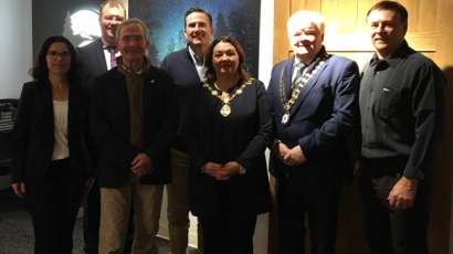
Cabox Geopark is one step closer to coming to fruition. After a Corner Brook city council meeting on Nov 18, the project now has the support of every community in the Bay of Islands region. The council approved and accepted the Strategic Tourism Areas and Regions Plan (STAR) report, a strategic tourism development plan for the Bay of Islands, Corner Brook and lower Humber Valley Area.
On November 13, IAT Co-Chairs Don Hudson of Maine and Paul Wylezol from Newfoundland joined Ulster Ireland mayors Michaela Boyle (Derry City and Strabane) and Nicholas Crossan (Donegal County) at a meeting with Appalachian Mountain Club President John Judge and Conservation and Recreation Director Heather Clish at their new headquarters in Boston, Massachusetts.
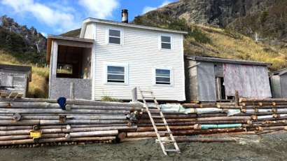
During 2019, the IATNL made significant strides in completing its Cabox Geopark basecamp at Stone Brook (aka Stowbridges) in North Arm, Bay of Islands. The two-storey former fisherman’s house will serve as a start/end point for 2-3 day treks across the North Arm Hills to/from Trout River. This year’s work included the installation of new cupboards, bunk beds, vinyl flooring, indoor plumbing, and the reconstruction of the damaged seawall.
In 2019 the IATNL added new signage to the Humber Valley Trail, including directional signage and memorial interpretive panels at both Scott’s Lookout on the west side of Wild Cove Valley and Barry’s Lookout above Humber Village. The latter two were designed in the James Cook inspired style of the new trailhead sign at Ballam Bridge, which was installed in 2017.
For many years now, Vermont maple syrup farmer and Appalachian hiker Lew Coty has travelled to Western Newfoundland in August to spend a month exploring the Long Range Mountains, the most northerly of North America’s Appalachian Mountain range. In 2019, in addition to making a Gregory Mountain trek with IATNL/CABOX director Paul Wylezol and a number of other shorter hikes, Lew set his sights on another hike of the West Hills between Trout River and Chimney Cove. These coastal mountains are part of the Little Port Island Arc Complex and are approximately 50 million years older than
During the summer of 2019, the IATNL made several exploratory treks into the Blow Me Down Mountains east of Blow Me Down Brook in search of new trail routes to connect the mountains to Benoit’s Cove and the new Cabox Geopark Information Center at Saltbox restaurant. Plan calls for routes to link to the IATNL Blow Me Down Mountain Trail and Cabox Geopark’s UltramaTrex.