
On September 2, Michigan long distance hiker Eric Moll became the first person to hike the complete IAT UltramaTrex in a single trek across the ultramafic sections of the Bay of Islands Ophiolite Complex from Fox Island River to Trout River. Eric began the 7-day hike with his twin brother Andrew, who had to pull out with sore feet after 5 days hiking across the Lewis Hills and Blow Me Down Mountains. This is the story of Eric’s hike, in his own words.

Eric Moll (left) with his brother Andrew at the IATNL Lewis Hills Trail southern trailhead on Day One, August 27
August 27-September 2, 2016
Arguably the finest hike in Western Newfoundland and some may even say Eastern North America, the UltramaTrex provides views of all four of the ophiolites of Western Newfoundland including the Lewis Hills, Blow Me Down Mountains, North Arm Traverse, and the Tablelands. The UltramaTrex is more of a route than a trail with significant portions of off-trail hiking. Highlights include the variety of hiking surfaces, many unique gulches, Newfoundland’s highest point, distant views, streams, lakes, wildlife, boat ride across Bay of Islands, and solitude.

Andrew Moll above Fox Island River
August 27
Our journey began at the Quality Inn in Corner Brook. IAT Chairperson Paul Wylezol provided us a ride to the remote southern trailhead in the Lewis Hills. We began our hike on a marked trail, one of the few that we would follow along the UltramaTrex. Highlights of the day included perfect weather, the Fox Island River, the Cabox (highest point on Newfoundland), many caribou sightings, a bear sighting and the perfect campsite at Molly Ann Gulch to enjoy a star-filled night.

Campsite at Molly Ann Gulch
Much of the route was marked with posts to the Cabox.

View across the eastern ultramafic section of the Lewis Hills
August 28
From Molly Ann Gulch the route was beautiful off-trail cross country travel.

Morning View of Molly Ann Gulch
In a short distance we reached Rope Cove Canyon.

We had several options for our descent to Serpentine Valley and decided to check out Bud’s Lake and also went to see an impressive lookout of the Serpentine Valley. We then made a steep descent into and around a gulch. We set up camp at the entrance of the gulch to the northwest of Wheeler’s Gulch.

August 29
Next morning we made our way over to Wheeler Gulch and could have climbed up a little but ended up bushwhacking our way to the cleared IAT to descend to the remote road walk to Serpentine Lake.

View up Wheeler’s Gulch
It started to rain lightly while we walked the road. There were some trailers and boats nearby but we didn’t see anyone. The Serpentine River flows swiftly and deeply from the lake so the route instructs to ford the lake. There were sticks stuck in the water to guide our steps. The water didn’t get much higher than our knees during the several fords.

Crossing the western end of Serpentine Lake, with Lewis Hills and Wheeler’s Gulch in background
We followed the trail marked with pink ribbons as we made our way to Simms Gulch. At times we had to make sure we weren’t off on a moose trail. We took a side trip over to a beautiful waterfall and then it started to rain.

Waterfalls below Simms Gulch
It was a very impressive hike through Simms Gulch and a steep climb out of it. We noticed blazes painted on rocks as we ascended between two streams.

Hiking up through Simms Gulch in the fog and rain

Up on top of Simms Gulch it was very windy and still raining. It was quite flat on top but quite wet everywhere. We reached another stream and looked for a place to camp but the only options were on top of grass on sitting water or being exposed to significant wind. After much searching we found a spot that was behind a small bush a ways above the stream.

Looking out the west branch of Simms Gulch
August 30
After sleeping a few hours I awoke at 2 am to significant wind nearly blowing the tent down. We spent the next 6 hours trying to keep the tent from breaking by providing manual support. Eventually we were able to take 10 to 30 minute shifts of trying to sleep. By 9am it was still the same wind and rain so we decided to pack up camp and start hiking. Visibility wasn’t the best and the terrain was simply grass as far as we could see in every direction. It was challenging to go straight as we had to dodge many small pools of water. After getting turned around once, we decided it was time to use a compass. Soon we reached Blow Me Down Brook Gulch and navigation was easier.

View across Blow Me Down Brook Gulch
The rain began to let up. We had several options and decided to explore Mad Dog Lake. The stream crossing on our map was quite significant due to the recent rain so we bush whacked upstream and found a safe place to cross. Some blue sky peaked through the clouds and it was pleasant hiking weather.

We continued past the southern end of Mad Dog Lake to a spectacular view of the Bay of Islands from the edge of the gulch.

View north across the Bay of Islands, with Woods Island at center
We didn’t identify the correct way down and ended up descending going south down to Blow Me Down Brook. First there were lots of big boulders, then a pleasant chute of small rocks with stable footing, then some bushwhacking through tuckamore, and finally more careful descending over rocks. We found a campsite on the other side of the brook.

Calm waters on Blow Me Down Brook
August 31
This was a short day. We hiked along Blow Me Down Brook. We didn’t find the IAT trail to Frenchman’s Cove so decided to cross over to the other side and follow the Blow Me Down Brook Trail to a nearby trailhead. There was a beautiful waterfall visible from the trailhead. Our parents had recently arrived and picked us up. Andrew decided the hike so far had been spectacular, but due to the water all over the route his feet were quite blistered. He determined he was in too much pain to continue. I decided to complete the final two days solo and purchased more food in Corner Brook.

Rattling Brook Waterfalls near the bottom of Blow Me Down Brook
September 1
Paul had arranged a shuttle for me from Cox’s Cove on the Middle Arm of the Bay of Islands. After arriving at Cox’s Cove a boat quickly pulled up and I met Sam. It was a beautiful day and the quick boat ride was very scenic. Sam dropped me off near Stowbridge Brook.

Fisherman Sam Park dropping Eric off near Stowbridge Brook
I began the North Arm Traverse with a beautiful climb up North Arm Mountain. There was a great view back of the Bay of Islands.

View of the Bay of Islands from the top of North Arm Mountain
The route went past several ponds and I saw two caribou resting on a beach. Near the evening I detoured off route for a better view of the Tablelands and Trout River Pond.

Evening view of the southern Tablelands
I found a scenic campsite above Beaver Pond.

September 2
The day started foggy and cloudy. The route paralleled Trout River Pond and I went over to the edge for the impressive view a couple times. I did have to be careful and plan ahead to avoid tuckamore.

View of the Tablelands across Trout River Pond
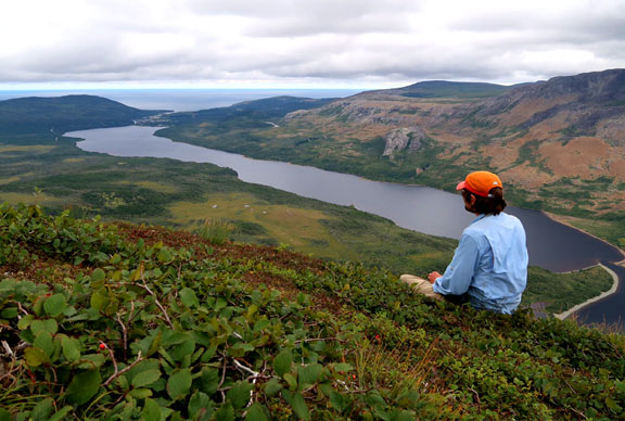
There was a spectacular view from Narrows Head of Trout River Pond (aka The Elephant) and out to the Gulf of St. Lawrence.

View of the Narrows and western end of Trout River Pond with Gulf of St Lawrence in background
I was careful to follow the route for the descent. I rounded a corner and found three moose staring at me. It was a steep descent through the forest and then down a steep, loose rocky slope. After crossing a stream and a significant bushwhack, I reached forest roads and I quickly reached the end of the route.

View of the Elephant from Gros Morne National Park boundary ATV trail
Even after completing other spectacular hikes around North America including the John Muir Trail, Wonderland Trail, much of the Colorado and North Country Trails, and a Wind River High Route, the UltramaTrex ranks as one of my personal favorites. The diversity of scenery and wildlife is exceptional. It is also very remote and we didn’t see another person the entire time we were hiking.

View of (L-R) Tablelands, Trout River Pond and the Elephant from near Trout River Pond Campground
Many thanks to the IAT for all the work designing and maintaining this outstanding route and for transportation and logistical assistance.
For more details on my UltramaTrex hike, come visit my hiking blog!
