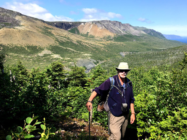
August 6-8, Appalachian explorer Lew Coty from Vermont, USA undertook a 3-day trek across the Bay of Islands north uplands in search of a St Gregory’s Arc hiking route from the southern end of the Gregory Mountains across the North Arm Hills to the IATNL basecamp at Stowbridges. He was joined during the first half of the trek by IATNL Chairperson Paul Wylezol who broke off midway to explore Lower Crabbs Brook.

In Lew’s own words:
Along the west coast of Newfoundland there is a vast stretch of highland wilderness extending from the Bay of Islands north to the Trout River Pond fjord. The southern end of this plateau is carved by the Lower Crabb Brook on its west side and Liverpool Brook on its east side. Mt St Gregory is the westerly height of land; the east side is dominated by the North Arm Mountains that rise out of the Bay’s North Arm. An International Appalachian Trail route has recently been developed starting from a base camp at Stowbridge Head just east of the mouth of Liverpool Brook, and heading north across the North Arm Mountains to Trout River Pond. The highlands west of this route aren’t so well known and not often explored.

During a previous trip to Mt Gregory I had gazed south down a long barren ridge that ends at the western end of the Bay. It looked like stellar hiking, and I had a bee in my bonnet to give it a go. Speaking with my friend Paul Wylezol, who is the chairperson of the IATNL and has developed much of the Newfoundland sections of the IAT, it didn’t take long for me to convince him that we needed to check out that south shoulder of Gregory.

August 6, 2019 After having spent the night at the IAT base camp, Paul arranged a ride with a local fisherman named Kerry Park to deliver us to the base of that shoulder. We rounded the headland west of the Lower Crabb Brook mouth, and were dropped off against a rugged shoreline after spotting a possible route up to the highlands where Kerry said he had seen moose ascending.

The first hundred feet up was a bit of an acrobatic challenge and unfortunately the moose trails above became braided and not well worn. Looking back I waved to our last contact with civilization for several days.

We zigzagged up the initial eight hundred feet, dodging tight growth and seeking out the moose runs wherever we could find them. The miserable hiking terrain was made a little more bearable by the dewberries that kept showing at our feet. It was especially frustrating looking at a barren ridge to the northwest that would have been so much easier to ascend, but was unfortunately separated from us by a deep gnarly valley.

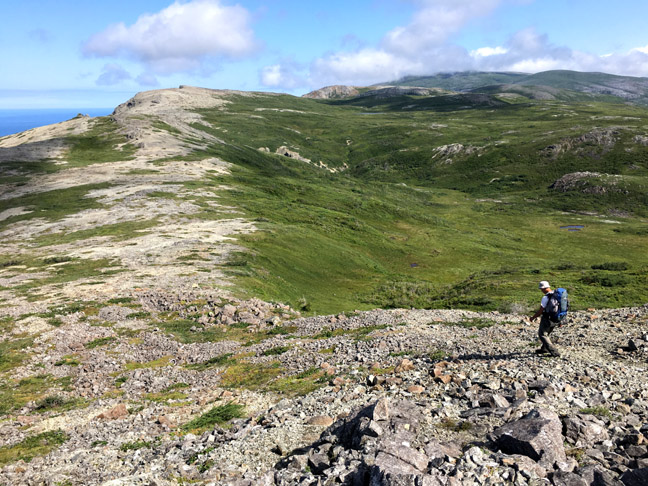
Finally on the ridge top, we proceeded northwest and popped out onto the open barren that pointed the way to Mt Gregory. The views immediately became spectacular as we could look down and across to the islands in the bay below

and up the cliff-lined shore to the north.

Heading up this ridge was a smooth rocky ascent, and the scenery became more detailed and enchanting with alpine ponds and corrugated topography always beckoning ahead.

We dropped into one brook canyon that had particularly vivid erosion features, and I dubbed it Chiseled Gulch [aka Davis Gulch].

Further north a pond popped into view below us with such striking streaks of emerald tinted water that I called it Bahama Pond.

Above this pond, Mt Gregory loomed clearly to the north, and gaining another thousand vertical feet brought me to its summit. It has no pronounced peak; two large cairns in fairly close proximity mark the height of land.

The plan from there was to traverse the high plateau heading east into the North Arm Mountains. We spent the night on Gregory’s east side, beside a headwater stream of Lower Crabb Brook.

Hiking west the next morning we skirted the rims of numerous canyons that drop into the Lower Crabb.

We soon came to the main event where two free leaping waterfalls drop in rapid succession. These I have named Stacked Falls, and they present a dramatic spectacle tumbling through their cliff-lined enclosures.

There are a number of seducing turquoise pools above, and considering the hot weather we were experiencing, I doubt if there is a human alive who could have resisted a dunk.

If the depth of those pools could be turned to stone what lovely jewelry could be made from it.

At this point we parted ways, with Paul heading south to explore the Lower Crabb Brook while I continued east to the North Arm Hills.

The most eastern of the high Crabb Brook canyons is a prominent large rounded one filled with green vegetation that I call Green Bowl. Above, and to both sides of this bowl vast stretches of impossible-to-traverse tuckamore made me apprehensive about my way forward. I skirted under the tuckamore to the top of Green Bowl, and followed a grassy lane east up a low-lying ridge. Blessedly this lane morphed into a well-worn moose trail that lead me over the ridge where it opened up into sprawling grasslands.

I was now hiking the divide between river watersheds and had entered the shallow upper end of the Gregory River basin. I followed the gentle contours of this grass-lined valley east, filled in places with blowing cotton grass

where roving moose traverse a remote landscape along the edge of Lower Crabb Brook’s East Fork, which meanders down below steep walled canyon. About two kilometers northwest of here is a peak I had visited before, topped with a large cairn that has a stunning 360° view of this entire highland area.

Proceeding east from here was a mix of grass with some stunted tuckamore that needed a little zigzagging to navigate through. As the Crabb Brook Valley began to to flatten on its eastern end, I came to one of its tributaries that gently flows over ledge surrounded by grassy slopes.

This waterfall that I’ve named Sue has very sensuous curves, and I’ve had a crush on her for a number of years.

I easily followed the grassy banks of Sue Brook down to the Crabb Brook, and was in amiable terrain I had explored in years past, close to the IAT route through the North Arm Mountains. Still heading east, I crossed over another low divide, entering the Liverpool Brook drainage. Traversing a couple kilometers of boggy terrain, I spent the night at a pond that drains directly into Liverpool Brook canyon.

I was now on a section of the IAT UltramaTrex route that traverses the Cabox Geopark going from north of Stephenville to south of Woody Point. This route heads northeast from here about six kilometers to a spectacular waterfall named Overfall.
Heading southeast next morning I crossed over into the North Arm Mountains. To the west I could peer down into the Liverpool Canyon where there is an impressive cluster of waterfalls. Hiking through some wetlands I passed by the bright red insectivorous Sundew and Pitcher Plant.

As I approached the North Arm of the Bay Of Islands to the east I entered peridotite barrens with their brownish-orange rock that is poisonous to most plant life.

I took a detour farther east to a deeply eroded drainage I call Delta Canyon. It empties directly into the North Arm with a distinctive alluvial fan at its base.

I then headed southeast along the North Arm rim back towards the base camp. It had been a cold late spring and there were large patches of snow lingering in some north-facing locations.

I easily spotted a ptarmigan crossing one of these snowfields. Its mottled grey plumage changes to white for the winter months, but it was very poorly camouflaged against the snow with its summer coat on.

I proceeded down a long oceanside ridge floating over the Bay

and arrived back at base camp finding Kerry working on his own camp.

Kerry is one of the most affable and down-to-earth fisherman you could ever hope to meet. We headed out, skimming across the bay in beautiful late afternoon light to pick up Paul at the base of Lower Crabb Brook, and then head back to our vehicles in Cox’s Cove.