During the Scottish winter of 2013, a team of eight Ayr Rotarians constructed a small footbridge across Mill Burn below Dunure Mains on the Ayrshire Coastal Path. The need became evident when the record wet year of 2012 demonstrated that stepping-stones placed across the stream proved inadequate to deal with major floods.
(l-r) Jimmy Begg, Harry Peters, Gus Iannotti, Douglas Haddow, and Neil Beattie
The bridge was designed by Jimmy Begg and approved by Harry Peters, a real civil engineer who once built a bridge over the Blue Nile! It is situated about 9 miles (14.5 kms) south of Ayr and half-way between the Robert Adam designed Culzean Castle and the fishing village of Dunure. Just after the end of WW2, the peoples of Scotland gifted life-time use of a top flat at Culzean Castle (owned by the National Trust for Scotland) to General Eisenhower for his part in D-Day and the liberation of Europe.
Culzean Castle
The landowner kindly gave permission for the construction of the small footbridge once the adjacent field of barley was harvested. But unfortunately for the volunteers, while making the most of the only dry week in September, the tenant farmer managed to harvest his crop and plough the huge field in four days - just before the delivery of three large telegraph poles and several railway sleepers!
Undaunted, the team of young lads (all of pension vintage) subsequently manhandled poles and sleepers down 500m of…
In March 2013, the Spain chapter of the Sendero Internacional de los Apalaches (International Appalachian Trail) honoured IAT Founder Richard "Dick" Anderson and IAT Spain honorary member Alicia P. Scribner for their roles in establishing the IAT and IAT Spain, respectively.
The presentation of an honourary scroll to Dick was made by Maine Chapter President Don Hudson on behalf of IAT Spain on March 28, during the Maine Chapter board meeting at Orono.
Maine Chapter President Don Hudson (left) with IAT Founder Richard "Dick" Anderson
The presentation of an honorary IAT Spain scroll to Alicia Scribner was made by IAT Spain Secretary Consuelo Paredes on April 7.
Consuelo Paredes (left) and Alicia Scribner on April 7.
Congratulations Dick and Alicia for a well-deserved honour!
In March 2013, England's Peddars Way & Norfolk Coast Path National Trail joined the IAT as a 150 km (93 mile) path that starts in Suffolk at Knettishall Heath Nature Reserve and follows the route of a Roman road to Holme-next-the-Sea on the north Norfolk coast. At Holme the Peddars Way meets the Norfolk Coast Path as it runs from Hunstanton to Cromer. The two trails joined as a Long Distance Path in 1986 in a ceremony performed by the Prince of Wales at Holme-next-the-Sea. In 1991 the name Long Distance Path changed to National Trail, and became the Peddars Way and Norfolk Coast Path National Trail.
The Trails are defined by a Roman road, unique Brecks, rolling open farmland, low cliffs, extensive sandy beaches, sand dunes and fabulous salt marshes. The majority runs through the Norfolk Coast Area of Outstanding Natural Beauty (AONB) and the Brecks, a unique area of forest, heath and low river valleys.
Visit the Norfolk Coast Area of Outstanding Natural Beauty website
The route of the Peddars Way has existed since Roman times and was built shortly after AD61 to enable troops to move through East Anglia for policing purposes, following the revolt and subsequent defeat of Boudica and her Iceni tribe. As with most Roman military roads it was built in a straight line, using local materials, to provide a fast link between the Roman garrison in Colchester and the Iceni heartland.
Statue of Boudica by Thomas Thornycroft near Westminster…
The Maine Chapter of the International Appalachian Trail participated in recent geological meetings in Canada and the United States: the 2013 Annual General Meeting of the Atlantic Geoscience Society in Dartmouth, Nova Scotia, and the Annual Meeting of the Northeastern Section of the Geological Society of America at Bretton Woods, New Hampshire.
Entrance to Bretton Woods, The Famous White Mountain Resort
Bretton Woods, The Famous White Mountain Resort
On February 1-2 2013, Maine board members Don Hudson, Robert Marvinney, Bill Duffy and Walter Anderson traveled to Dartmouth Nova Scotia to meet with officers and members of the Atlantic Geoscience Society (AGS), and to deliver a talk entitled: “The Role of Geology in the Development of the International Appalachian Trail” by MIAT members Walter A. Anderson, Robert G. Marvinney, Douglas N. Reusch, Julia Daly, and W. Donald Hudson. Our participation was acknowledged with hospitality and enthusiasm by AGS President Elizabeth Kosters and members of the AGS. Among others, two very important connections were made with John Calder, Senior Geologist with the Nova Scotia Department of Natural Resources Geoheritage Program, Halifax, NS, and Randall Miller, Head of Geology and Paleontology, Research Center, New Brunswick Museum, Natural Science Department, St. John’s, NB.
IAT North America Geologist Walter Anderson at the IAT Exhibit
On March 18-20, Board members Walter Anderson and Bill Duffy traveled to the Annual Meeting of the Northeastern Section Meeting of the Geological Society of America…

On March 2 – 3, the IAT North America Council gathered in Moncton, New Brunswick to discuss issues of common interest, report chapter progress, and relax with friends over good food and drink! Topics for discussion included IAT maps and trail markers, websites and social media, corporate sponsors and long-distance hikers, and IAT Europe and the 2013 AGM.
On March 2 - 3, the IAT North America Council gathered in Moncton, New Brunswick to discuss issues of common interest, report chapter progress, and relax with friends over good food and drink!
Topics for discussion included IAT maps and trail markers, websites and social media, corporate sponsors and long-distance hikers, and IAT Europe and the 2013 AGM.
IAT North America Geologist Walter Anderson discussed meetings and presentations at North American Geological Societies where he introduced the IAT project to a diverse audience of North American geologists.
Will Richard from IAT Maine, gave a presentation on his new book Maine To Greenland, Exploring The Maritime Far Northeast, much of it in "Appalachian" territory,
while Bill Duffy used the opportunity to present an updated version of his IAT Appalachian Domain map.
As usual, the IAT Council Meeting weekend closed out over dinner and drinks!
Next stop: September 18-20 at the IAT AGM at Scotland's magnificent Loch Lomond and The Trossachs National Park !!
Click here for more details on the 2013 AGM.
At the 2012 IAT Annual General Meeting in Reykjavik, Iceland, the Iceland Touring Association's Kjalvegur hinn forni (Old Kjalvegur hiking trail) became an official part of the International Appalachian Trail. The former horse track extends approximately 40 kms (26 miles) through a highland dessert valley between Langjökull and Hofsjökull glaciers.
Like Sprengisandur highland road, the area was probably known since the first times of Icelandic settlement and is mentioned in the Icelandic sagas. The track along Langjökull was used as a shortcut between regions during summer, with piles of stones still marking the treeless track across the barren terrain. After a number of people perished in snowstorms during the 18th century, the primitive road was forgotten for about 100 years and rediscovered in the 19th century.
When you cross Iceland via Kjalvegur you drive through a barren land sandwiched between great sheets of snow and ice. Before the age of cars when everyone travelled by horse, the route was further to the west closer to Langjökull glacier, because of the richer vegetation. This is where the Kjalvegur hinn forni (Old Kjalvegur) hiking trail is today. Because the trail is relatively flatter and easier to walk, many people consider it a good preparation for walking the Laugavegur Trail, one of the most popular and well travelled hiking trails in Icelandic.
Hofsjökull Glacier
The trail between Hvítánes and Hveravellir can be walked from either south to north or vice versa, and…
In February 2013, the UK's Offa's Dyke Path National Trail joined the IAT, bringing with it Britain's longest ancient monument while creating a 1,047 mile (1,675 km) IAT Wales loop with the Wales Coast Path. The 177 mile (285 km) long, 1200 year old linear bank and ditch passes through no less than eight different counties and crosses the England/Wales border 20 times. It explores the tranquil Marches (as the border region is known) and passes through Brecon Beacons National Park on the spectacular Hatterall Ridge. In addition, it links no less than three Areas of Outstanding Natural Beauty – the Wye Valley, the Shropshire Hills and the Clwydian Hills.
Brecon Beacons National Park
The Path was opened in the summer of 1971, linking Sedbury Cliffs near Chepstow on the banks of the Severn estuary with the coastal town of Prestatyn on the shores of the Irish Sea. It is named after, and often follows, the spectacular Dyke which King Offa ordered to be constructed in the 8th century, probably to divide his Kingdom of Mercia from rival kingdoms in what is now Wales.
Although people have been rumoured to complete the Path in four days, more typically two weeks are about right for the whole journey. Of course many people choose to complete only short sections in day trips or to complete the whole Path over many weeks, months or years! There are regular…
In January 2013, England's Ridgeway National Trail joined the International Appalachian Trail as "Britain's Oldest Road."
The 87 mile (139km) path crosses ancient landscapes on both sides of the River Thames, following the same route used since prehistoric times by travellers, herdsmen and soldiers. It passes through two distinctive landscapes: the open downland to the west of the Thames within the North Wessex Downs Area of Outstanding Natural Beauty, and the more gentle and wooded countryside of the Chilterns Area of Outstanding Natural Beauty to the east.
The route follows a chalk ridge cut in two at almost its mid-point by the Goring Gap through which the River Thames flows. The chalk started to form about 100 million years ago beneath the seas, and the landscape we now see began to take shape around 30 million years ago as Africa collided with Europe. This caused the rocks in this area of England, including the chalk, to tilt very slightly towards the southeast. The result of this is that the northern edge of the chalk drops down as a steep hill, or scarp, to flat valleys below, while the chalk plateau declines gently away to the south.
For at least 5,000 years, people - including drovers, traders and invaders - have walked or ridden The Ridgeway, part of a prehistoric track once stretching about 250 miles (400 km) from the Dorset coast to the Norfolk coast "Wash." It provided a high ground route…

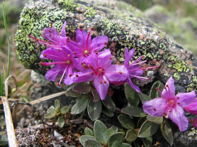
January 2013 marks the introduction of two new website series on the Natural and Cultural Heritage found along the International Appalachian Trail, from eastern North America to Western Europe. This first piece on Natural Heritage by Beyond Ktaadn was excerpted and adapted from their new Eastern Alpine Guide, and is titled: Common Alpine Plant Species along the IAT in North America.

From August 22-23, Long Range Adventurer Lew Coty made a circumtrek of Gros Morne National Park’s Trout River Pond, beginning at the trailhead to Trout River Pond Trail. The two day trek brought him across the top of the Tablelands, down around the back end of the pond near Overfalls Trail, and up and across the south side hills, with a final descent down the head of the Elephant.
January 2013 marks the introduction of two new website series on the Natural and Cultural Heritage found along the International Appalachian Trail, from eastern North America to Western Europe. The IAT Natural Heritage series will showcase concise illustrated stories on both nature and geology, while the IAT Cultural Heritage series will include stories on e.g. human history, art, and architecture.
This first piece on IAT Natural Heritage by Beyond Ktaadn's Mike Jones (IAT North America Alpine Ecologist), Liz Willey, and Marilyn Anions was excerpted and adapted from their new Eastern Alpine Guide, and is titled:
Common Alpine Plant Species along the IAT in North America
From a botanical perspective, one of the more striking differences between the Appalachian Trail (in the strict sense, from Georgia to Maine) and the International Appalachian Trail (the corridor from Katahdin to the Great Northern Peninsula of Newfoundland) is the diversity and extent of alpine tundra ecosystems found along the latter (Figure 1).
Figure 1. Extensive alpine and subalpine plant communities occur along the length of the IAT in Maine, Québec, and Newfoundland. (Mont Logan, Québec)
While the AT traverses notable tundra areas on Mount Moosilauke, Franconia Ridge, and the Presidential Range in New Hampshire, and Katahdin in Maine, the IAT not only traverses Katahdin, but also cuts across tundra communities along the Mont Chic-Chocs and Mont Albert and Mont Jacques-Cartier and the Monts McGerrigles in Québec, and Table Mountain, the Lewis Hills, Blow Me Down, the North Arm Hills, the Long…

