From August 22-23, Long Range Adventurer Lew Coty from Vermont made a circumtrek of Gros Morne National Park’s Trout River Pond, beginning at the trailhead to Trout River Pond Trail. The two day trek brought him across the top of the Tablelands, down around the back end of the pond near Overfalls Trail, and up and across the south side hills, with a final descent down the head of the Elephant. In his own words and photos, below is another chapter in Lew Coty’s Long Range Adventures.

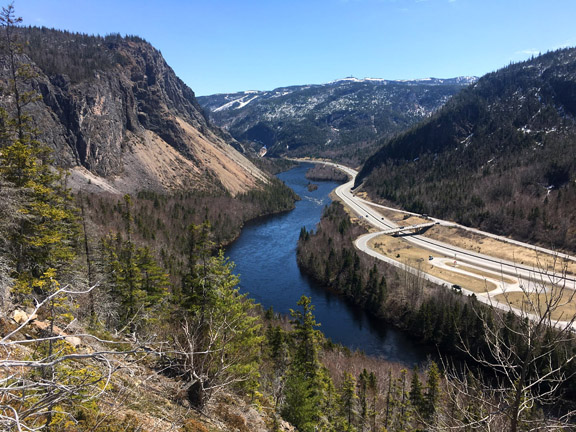
 “I have spent a good part of many summers in the Trout River area of western Newfoundland, and am mesmerized by the view into the fjord that Trout River runs through before draining into the ocean. This fresh water fjord, called Trout River Pond runs about 15 kilometers inland, following a southeasterly course. It is in two parts, separated by an hourglass-like restriction about a third of the way up, called the Narrows, which is barely large enough to let boats pass through. Downstream from the Narrows is called Small Pond and it is all you can see from the lower end, though the majority of water lies upstream in Big Pond. Vehicular access is limited to the base of Small Pond. South of the Narrows is a jutting headland called Narrows Head, with an imposing steep rocky face called the Elephant, which does look much like an elephant’s head when viewed from the front. On the north shore of the pond, a gentle seven-kilometer trail runs up a little past the Narrows. Beyond this are craggy canyons where streams cascade off the peridotite plateau above, called the Tablelands. I began feeling deprived that I never really got to know Big Pond intimately, and found myself on a mission to hike clockwise around this fjord.

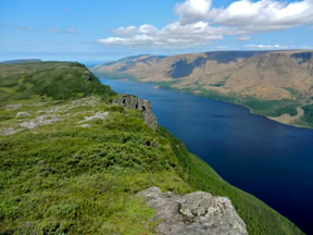
View of the Narrows and Elephant
August 22/12: The weather forecast was for two good days, but that is not what I awoke to. The view up the pond looked partly sunny, but the scene to the west over the ocean was ominous with an opaque layer of dark clouds headed my way. I stopped by the docks to ask the local fishermen what they thought the day’s weather might bring. One said what looked obvious, that it was going to be rainy at sea but okay over the mountains. The second fellow told me the exact opposite. I was chafing at the bit and quickly concluded the first opinion must be right. As it turned out they were both right.

 As soon as I began hiking the trail up the north shore, it began pouring rain, which lasted all the way past the Narrows, where that dismal cloud layer finally began breaking up, letting filtered sunlight through. My intent from here was to climb up onto the Tablelands by ascending Fox Point Brook Canyon. As I entered the canyon, its top was still in the clouds, but the view to the west was bright and sunny which lightened my step. It was fairly easy going for a few kilometers until I rounded a corner where I could see the brook dropping off the Tablelands in a long-winded waterfall, with precipitous slopes on both sides. It was naive to have thought I could get through that canyon but sometimes God leads the naive, and such seemed to be the case as I immediately fixated on a lone side canyon to my left that looked like a possible way out. Fortunately it turned out to be a good exit, and as the clouds nesting on the Tablelands finally lifted, so did my spirits.
I soon found myself looking down onto the winding Fox Point Brook far below, as I hiked into the orange colored peridotite Tablelands. For a stretch, I wove through fens before reaching the high brim above Big Pond.

I proceeded, skirting the tops of V-shaped canyons. At one point, as I approached the upper end of Big Pond, looking northeast over Pic a Tenerife and Bonne Bay, I could see Gros Morne Mountain in the distance.

I descended from the Tablelands over a grassy slope and headed west toward the headwaters of Burnt Brook which I hoped would lead me, without much effort, to the top of Big Pond. I was half right: it led me there, but with great effort. The first kilometer over mostly open grasslands was fine, but dropping into and following Burnt Brook was frustrating, with much scrambling down slippery ledge and around numerous waterfalls. I fought my way through tight tuckamore and over areas of multiple blow-downs. It proved to be the most miserable section of this trek. When I finally arrived at the upper shore of the Big Pond, the sun was low.

I welcomed the easy walking along the sandy shore, but was soon forced to hike around a deep narrow bay of water. This detour involved a half-kilometer battle with tightly-entwined alder bushes. I finally came to the Overfall Trailhead and dock, which are accessible by boat. I followed the trail a short way into some open woods where I set up my tent in failing light, ate a quick snack, and fell asleep instantly upon becoming prone.
 August 23: I was grateful to awake under a sunny sky and hurried off up a stream that flows from the west into Trout River not far above Big Pond. A spruce grouse alerted me to its presence by its red patch over the eye, and as usual for this type of bird, he let me get within a few feet before moving on. With such behavior, I am astounded they can survive in the wild.
I was heading for the 99 on my topo map, which marked a 99-meter waterfall. This was a respectable drop and needed to be checked out. Ascending the stream, I drifted to the left into some semi-open terrain where I could get an occasional eclipsed glimpse of the falls. Progressing onto higher ground I saw the full picture of two waterfalls converging into one near their base, and I immediately named it Forked Falls. This waterfall lives in the shadow of its near neighbor Overfall, and though it doesn’t possess the flamboyant power of Overfall, it is still a distinct and impressive fall of water.  Climbing through a pleasantly open forest, I topped out onto the upper plateau, and sat to have breakfast on the bank above Forked Falls Brook. To my left was a smaller waterfall plunging off higher ground, and directly in front of me at a lower level was a large clearing connected to the barrens running north. I was marveling at how brooks like this one often make gurgling noises, which sound identical to human voices. Then I did a double take, hearing what were unmistakably human voices. To add to the confusion of the moment, I suddenly saw a lone man walking across the clearing towards me with no backpack! I rubbed my eyes in disbelief thinking maybe I had lost my sanity after waiting too long to eat. As it turned out, he wasn’t a hermit surviving in these barren hills, but was with a group of fellows from St John’s, and they were photographing themselves hiking across the clearing with the waterfall in the background. They were coming from Crow Head and were being picked up by boat that afternoon at the head of Big Pond. This area is infrequently visited, and the odds of our paths intersecting in this remote location are astronomical. It was obvious they thought my solo endeavor was ludicrous at best.
Hiking north from here, I kept eyeing where it looked like a giant had taken a cleaver to the ridgeline. Scrambling up to the rim I peered into topography looming over Trout River Pond that had seen some trauma in its geological past.

I was now heading northwest along the rim towards Narrows Head.

My intent was to hike down the Elephant though I had no idea whether I could do this, especially with a backpack on. The profile view I had from the north side of the pond while hiking in looked impossible, though I knew the slope was gentler in the middle, directly over the trunk.
 Hiking straight over this face would make for a dramatically direct descent, while detouring around looked like a lengthy and gnarly proposition. The safety concern of an Elephant descent weighed on me as I approached it. I was also running out of open terrain as I progressed, and began making wide zigzags to avoid the tuckamore. Near the end of this section, I followed a path where the park boundary had been cut, leading to the base of Narrows Head where the terrain opens up again.
I reached the summit of Narrows Head and tentatively hiked to the rim of the Elephant over the right ear. A dizzying drop to the pond met my eyes and it became clear that finding a backpacker’s route down this was probably not realistic. However, before giving up completely I needed to examine the area between the ears.  Coming to the brow directly over the trunk I saw I could easily descend the first couple hundred feet, though you couldn’t see past that due to the curvature of the drop. And, so it went all the way to the shelf area halfway down the trunk where, looking at the sheer drop to the water, I began to get worried again. I saw a boat slip through the Narrows below, and waved as I thought perhaps it might be the group I had met, though it would have been a miracle if anyone had seen me. Hiking the circumference of this lower rim, my hopes for finding an escape route disintegrated. I was quite averse to the idea of hiking all the way back up, but at the moment, no other options existed. I had only hiked up a few hundred feet when I wandered to the west and came to some scree slopes leading to cliffs below. As I got near those cliffs, I veered to the right into a forest of stunted trees and was soon at the base of the Elephant!

From here, a series of lowland barrens with connecting woods roads lead to the main road, coming up from the lower end of Trout River Pond. Fortunately, I had examined these closely during my descent, and so my hike out was happily uneventful.”
Lew Coty