On September 3, 2017, Loren Butler and his buddy Doug Harrison combined two hobbies and made a S.O.T.A. trek to the Cabox on Lewis Hills, the highest point on the island of Newfoundland. Summits On The Air is an amateur radio activity geared for the more adventurous radio enthusiasts who carry radio equipment to a summit and “activate” it by making contacts. Follow along on Loren and Doug’s adventure to the Roof of Newf.

“It all started around a kitchen table as all great discussions do. Me and my best friend Doug were talking about our next epic and foolish adventure. Our mutual love of the Newfoundland wilderness and outdoor hobbies gets us into great little adventures. Doug told me about his previous hiking trip to one of Newfoundland’s highest hills. I was giving serious thought on doing it on my own, then he said he wanted to hike Newfoundland’s highest peak known as the Cabox. That sparked a fire that wouldn’t die down in my mind. The Cabox is located on Newfoundland’s west coast roughly between Stephenville and Corner Brook. The area is known as the Lewis Hills. It is also part of the International Appalachian Trail. It towers above all other hills in Newfoundland at an elevation of 2670 ft (814 meters). After several follow up get-togethers we kept talking about it which eventually lead to him asking me … soo are we doing this or what? …to which I replied name the date. We settled on Sept 3rd as it worked out work wise for the both of us and we figured at the later part in the year the rivers we would have to cross would be at their lowest and the bogs and barrens will be at their most dry.

While waiting for the hiking day to arrive, I thought it would be great to combine one my favorite hobbies amateur radio with the hike. I thought it would be great to operate S.O.T.A. (Summits On The Air) while at the Cabox. S.O.T.A. is a part of amateur radio geared for the more adventurous. It involves taking your radio equipment to summits / hills / peaks and *activate* it by making contacts. You need just 4 contacts with other radio operators to activate a summit. However, you are not limited and the more you make the better. Not just any hill or peak will qualify as a S.O.T.A. The head association has guidelines that define what qualifies as a peak for example its height. I had one hurdle to overcome. After some research I realized without an S.O.T.A. association in place no S.O.T.A. could be official. Time was rushing towards September so I made a huge push to start one. After a lot of research, emails, documentation and a lot of help the work got completed. It entailed breaking the province into regions and then figuring out what areas are classified as a summit.

Then figuring out the name of each summit. This is usually a very long process, however I had a lot of help. I volunteer with three search and rescue teams and have made many friends across the province, especially with the search and rescue teams. Through my friends and volunteers network I was able to find the names of many of these areas. Sometimes I had to refer to topographical maps to obtain the names, as some areas were very remote or local names did not exist for them. With the Cabox being the highest, I made it #1. As of Canada Day, July 1st 2017, all of the i’s were dotted and t’s were crossed and Newfoundland’s S.O.T.A. association was official.

Activating a summit is fairly simple, when you decide on a date post an alert (1) on the S.O.T.A. watch site. This will let other people know when you will be activating a summit and what frequencies you intend to use. It certainly helps when making contacts. Once you have hiked to the summit you can place yourself on another part of the website (2) to let people know you have started. When you have arrived back from the SOTA trip you need to log your contacts (3). It is good practice in general for all radio operators to do so, but without confirming who you talked to your activation may not be considered successful. Even if you do not get a successful activation (4 or more contacts) it is a good idea to log your contacts in their database. For more information about S.O.T.A., go to the main SOTA website (4) where I have started a SOTA web page specific to NL (5). You can also sign up for the SOTA reflector (6) which is a more interactive forum filled with lots of hints tips and information.

With the SO.T.A association in place, my amateur radio gear situated, our track mapped out and all our gear packed up, we hit the highway. We lucked out weather-wise and as we traveled, it kept getting better and we ended up having a 3 day stretch of perfect sunny weather and perfect temperatures for hiking. We could not believe our luck. It took a better part of a day to travel from the east coast over to Stephenville, where we followed a woods road up as far as we could. That evening we made basecamp and prepared everything for the next day. By the time the sun had gone down, all the clouds in the sky had disappeared and every star and constellation were lit up like 100 watt lightbulbs. I can point out the major ones, but Doug was an amateur astronomer as well and without missing a beat was pointing out almost every star and constellation. We could have stayed up for hours just staring at the sky, but we had a very rough 24 KM hike awaiting us the next day and morning was approaching fast.

We awoke just after 4am in the morning. The unpleasantness of such an early rise was quickly brushed aside as the stars we saw the night before were still in the sky. Breakfast was quick and easy and off we went. A very wet bog was the first to greet us. It was fairly easy going at first, with small rolling hills and a mixture of grassy and boggy hills to traverse across. It was difficult only because it was still dark and we were running on flashlight and twilight. We came to our first big dip about 3km in. We said goodbye to the few moose along the way as well as a few partridge. The sun was just popping up over the hills and the entire area was painted in sunlight showcasing one of the most amazing and beautiful sights I had ever seen. Other than the river below us that we would have to cross, you would have thought you were on mars. Beyond the river a huge 400m gorge carved by wind and water we would have to climb. The river felt bone chilling, but with the lack of a coffee shop drive through it was a needed perk up.

We continued up the large gorge and on top it felt like we were in northern Labrador. The temperature and terrain took me back to my childhood living on the northern parts of the province. As good as I am in picking out and knowing plants and berries, Doug’s experience with a previous employment made him much better. We were able to determine flowers, berries and shrubs that typically only grow in northern Labrador or even more northerly. I even picked up some Labrador tea plant leaves to make some tea once I was back home.

From the top of the gorge hiking got a lot easier. There were still lots of uphill and downhill climbing to do, but nothing as bad as we had previously experienced. The sun was now high in the sky and was certainly not shy of providing more heat than I wanted with 30lb of gear on my back and still more hills to climb. As well, we had lots of little ponds and rivers to hop across and maneuver around. About an hour later we had a visual on the peak. Although the terrain was a rolling hillside, there was no mistaking what was right in front of us and we trekked onward.

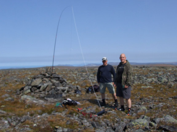
By the time noon had come we had made the 12 km journey and had climbed to the top. A herd of caribou and a large rock pile greeted us. At the very top there is a plaque to commemorate the spot. We marveled at the beauty around us and took pictures. As anyone who knows me can attest to, I have a funny quirky personality so I had to take a picture with the plaque in my own special way. I then settled in to setting up my radio equipment. Moments later I was calling out for anyone to come back to me, worried that after all the walking and gear lugging I would not be able to make my 4 required contacts. Luck was on my side and in 20 minutes I had 4 in the log book. I kept going until we had to pack up for the 12km hike back. I ended up making contact with radio operators from Ontario to the U.S. states of MI, MA, CT, PA, OH, NJ, VA and more. It was not the best time of day to contact European stations and we did not want to stay on the summit too long, as we had another long walk back.

Content with the contacts and with time running short, I packed up the gear and we headed back following the same path we took coming in. We made excellent time and were able to land back to base camp in the early evening. We got back just in time to see two moose near basecamp.

A well-deserved meal and a glass of something strong was in order. We both slept like a log that night and continued on home the next day. Growing up in rural Newfoundland I have grown up with a love for its geographical beauty and an appreciation for its animals and wildlife. This amazing trip was the pinnacle of both. I was able to combine my love and passion for this beautiful province with the (in my opinion) best hobby in the world.”

1 http://www.sotawatch.org/alerts.php?action=new
2 http://www.sotawatch.org/spots.php?action=new
3 http://www.sotadata.org.uk/AddActivation.aspx
4 http://www.sota.org.uk
5 http://www.linuxwolfpack.com/nlsota.php
6 http://reflector.sota.org.uk