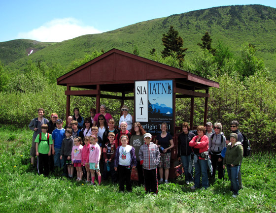
On August 1, 2016, Appalachian hiker and explorer Lew Coty from Vermont, U.S.A. set out from Route 430 (Viking Trail) at Southeast Hill in Gros Morne National Park on a two-day trek to Gros Morne Mountain. Follow Lew in his own words as he hikes up Burridge’s Gulch and heads north across the Long Range Mountains on one of his many perennial solo treks of Newfoundland’s Appalachian Mountains.

“Driving east on Route 430, passing the East Arm of Bonne Bay, you climb onto the Southeast Hills, and as the road begins to level you can see the highland barrens tumbling down almost to Southeast Brook just north of the highway. Traversing the high, windswept barrens of Gros Morne Park is truly a magical experience, but unless you’re blessed with a groomed trail leading there, accessing them is usually not. This entrance to the upper elevation fairyland was no exception.

August 1,2016: Leaving the highway and crossing Southeast Brook is no problem as the water in this area runs gently and shallow. However, at this point the sloping barrens that look so close from the road are still a half-kilometer away. A half-kilometer just isn’t that far, but when it involves hacking through tightly-entwined conifers and alders, while clawing your way up a steep slope with a backpack weighting you down, it can seem interminable. This is not an enjoyable way to begin my trek northward to Gros Morne Mountain, where a maintained trail will lead me back to the highway, and I soon begin asking what in God’s name I’m doing it for.

The answer comes quickly as I finally ascend and approach a cairn perched on the south end of the exposed terrain, at the brim of the ledgy drop. It is comforting to know that at least one other soul was stubborn enough to forge that gnarly climb so they could take in this stellar view. The airy vista includes the headwaters of Southeast Brook to the east, Bonne Bay basin to the west, Burridges Gulch canyon to the north, and to the south you can look over the Southeast Hills and Lomond River to see the orange peridotite barrens of the Tablelands poking above the horizon.

Heading north I follow a ridgeline of rocky folds for a kilometer, where I interrupt the serenity of a ptarmigan, who as usual is looking cautious and timid with every step. In contrast, a raven barges in on the highland breeze, landing nearby looking smug and invincible.

As I advance toward the north end of Burridges Gulch, the hiker-friendly, ledgy terrain morphs into swaths of tuckamore, which are fortunately laced with winding green beltways. Weaving through these grassy lanes that are frequently intercepted by small lakes gives intrigue to the hiking.

Every lake I approach gets me thinking this is the most beautiful body of water I have ever seen until I come to the next.

These lakes drain into brooks that quickly spill their contents over the steep walls of Burridges Gulch.

North of the gulch where the terrain opens up, I find rolling grassy slopes often lined with ferns or boulders.

I come to a lake nestled into the hills with a pronounced peninsula that begs to be hiked to its terminus.

Fruit breaks are irresistible as bakeapples (that I need to bend over for) and high-bush blueberries (that I don’t) become ubiquitous.

At this point my route turns west, the terrain flattens, and the lakes and sky grow noticeably in breadth. I high-step through numerous bogs over a green blanket of spongy sphagnum moss. These wet areas are home to cotton-grass whose fibrous seed masses blow like flags in the breeze, and sundew with its eerie sticky tentacles that trap insects.

Now heading north again, I come to sweeping grasslands interspersed with large lakes and scarred by moose trails, some with multiple lanes. Deciding it best not to test my right of way with these burly animals, I wander around them when they get in my line of travel.

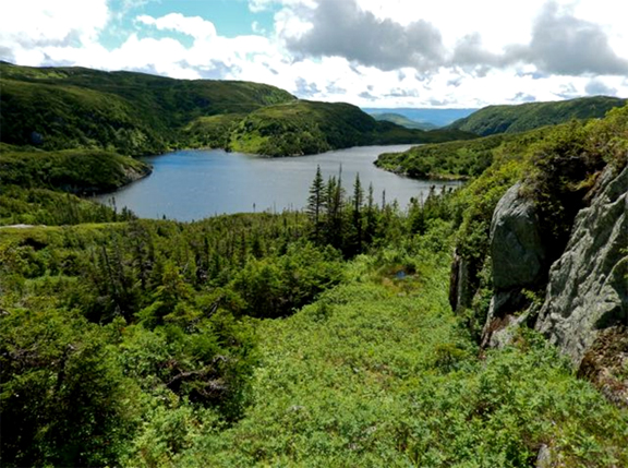
I am soon crossing the headwaters of the mighty Rocky Barachois Brook at the mouth of Barachois Pond. Hiking up the pond, the silhouettes of trees that have succumbed to this harsh windswept environment look like ghosts in the fading afternoon light. I follow a cobbled stream bed to a feeder pond further north and set up camp.

August 2: The unworldly sound of loons, which I can only attempt to describe as a baby trying to yodel, awakens me early in the morning.

I head north from here trekking over level, amiable ground broken by jigsaw-shaped lakes and their connecting brooks. Looking to the horizon I begin to see Gros Morne Mountain with the cliff-faced rim of Ten Mile Gulch behind.

Dabs of color at my feet keep interrupting my gait.

Green Island Pond soon reveals itself, and hiking its east side I look across at the numerous hilly mounds rising from its west shore. Both the north and south end of the pond offer a lofty 360-degree view of this highland lake and plateau

On the final push north I come to the Long Range Traverse, a well-traveled route going from Western Brook Pond on the north end to Gros Morne Mountain. As I head west down this route I can’t help but think what a perfect extension this trek would be for that route. East of Gros Morne I come to a classic view looking down to the inland fjord of Ten Mile Gulch.

Whale-backed Gros Morne Mountain comes into full view, and I drop into Ferry Gulch, the valley on its south side, and follow a crowded trail out, feeling I have re-entered civilization.”
Lew Coty