On August 22, IAT Chairperson Paul Wylezol, IATNL Vice Chair Arne Helgeland, and IATNL Signage Director Delano Pittman made the first thru-hike of the IATNL Iceberg Alley Way between St. Carol’s and Great Brehat on the tip of Newfoundland’s Great Northern Peninsula. They were joined by hiker/filmmaker Mark Flagler, who was in Newfoundland beginning work on his IAT North America adventure documentary.
The day began with a surreal mist enveloping the large icebergs and small fishing boats in St. Carol’s harbour.

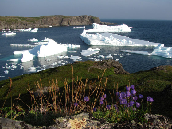
Slowly the rising sun lowered the mysterious veil to reveal a quaint little fishing village surrounded by blue water, white ice, grey rock and a green carpet of shrubs and mosses.

View Video of Icebergs in St. Carol’s Harbour
Leaving St. Carol’s, the foursome walked along the low barren hills overlooking the north side of the harbour for a half-kilometer until they reached the windswept point of land jutting into the North Atlantic Ocean.

From there they turned north and walked one kilometer up an easy gradual slope with great views of the surrounding ocean and harbour, until they came to sheltered Line Head Cove on a ruggedly scenic serrated coastline.

Hidden below amongst the rocks and ice was a solo kayaker paddling in for a break.

From here the route follows the mossy coastal hilltops for another kilometer

View Video of Hiking the Iceberg Alley Way
to an unnamed indented coastal depression with a great profile view of the battered shoreline.

View Video of the Rugged Coastline
Another kilometer north is picturesque Square Bay, with its snug harbour for hidden icebergs.

The bergs here were close enough to touch

View Video 1 of Iceberg in Square Bay
while the foaming surf provided nature’s soundtrack.

View Video 2 of Iceberg in Square Bay
Just north of Square Bay an encounter with a southbound walker provided no new information on the last three kilometers of the route to Great Brehat.

However before long – and after dodging a few patches of coastal scrub – the desolete yet scenic entrance to the harbour comes into view,

and after a gradual descent from a height of 300ft elevation, the small historic village appears out of the western landscape.

View Video of Great Brehat Harbour
A French fishing station was established here more than 200 years ago to pursue the salt cod fishery.

Today fishing continues, with local fishers saying they fish as far away as the lump fishery in Hare Bay, some 20+ kilometers to the south.
In all the Iceberg Alley Way between St. Carol’s and Great Brehat traverses 8 kilometers of coastal barrens, and can be completed comfortably in approximately 4 hours.
After completing their trailblazing trek, our Group of Four returned to St. Carol’s where the sky was now bright and clear, and seals were tanning on the even brighter white ice.


From there they made the short 5-minute drive to St. Anthony Bight, where they found a stealth campsite for the night … and toasted the day’s catch of ice!

(left to right) Paul Wylezol and Mark Flagler warming up while cooling down