In August a group of hikers, including IAT President Paul Wylezol, IATNL Secretary Caroline Swan, and Signage Director Delano Pittman, made a two-day mountain trek from the Starlight Trail in Codroy Valley to Table Mountain east of Cape Ray. The goal was to explore the region for the planned Grand Codroy Way, the most southern IATNL trail in Western Newfoundland’s Long Range Mountains, which in turn is the most northern section of eastern North America’s Appalachian Mountain range.

The beautiful and fertile Codroy Valley was settled in the 19th century, largely by Scots from Nova Scotia’s Cape Breton Island. The early economy was based largely on fishing, agriculture, trading and boat building. Common family names still include MacIsaac, MacNeil and MacDonald, and their Mc counterparts.
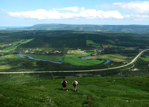
The Valley’s Starlight Trail begins on the eastern side of Little Codroy River at the former Starlight Motel parking lot. It rises 1200ft (365m), and provides good views of the Little and Grand Codroy Valleys,

Campbell Lake,

and the Long Range Mountains and coastal plain to the south.

The Codroy Valley Area Development Association began work this summer on a project to upgrade the lower section of trail, including construction of new boardwalks where needed.

Leaving the Starlight Trail, the Group of 8 hikers climbed to 2,000 feet (610 meters), and before heading south, took a 2 kilometer (1.2 mile) detour to the top of the waterfalls and gulch east of the community of Doyles,

separately encountering a caribou stag and calf along the way.

Day One of the trek was followed by a spectacular mountain sunset – a good omen for Day Two!

IATNL Secretary Caroline Swan and her boyfriend Jamie enjoying the colorful sunset
As nature predicted, Day Two began with a beautiful blue sky above a lush green sea of grass and moss, dotted with intermittant clouds, ancient rock, and colorful wildflowers, rolling across the hills from gulch to gulch.


The grass and moss makes walking and navigating this area as effortless a trek as one can find on the Long Range Mountains. Apart from signage and the erecting of cairns, the only trail work required is a day or two cutting through low scrub above Trainvain Gulch.

Delano Pittman above Trainvain Gulch, with Wreckhouse and the Gulf of St Lawrence in the background
The southern end of the planned Grand Codroy Way provides fantastic views of the Gulf coast and Long Range Mountains near the entrance to Codroy Valley, as well as Big Pond below Table Mountain.


The northern end of the 4-day trail will be near Mollichignick Brook, after crossing Little Codroy Pond Valley. But you will have to plan for 5-6 days, since the Wreckhouse area of Newfoundland is known for high winds and toppled trucks!
However don’t let that slow you down. You can always weigh down your pack with glacial erratic rock, to keep your nose to the wind and your feet on the ground!!!
To view more photos from Starlight Trail to Cape Ray, go to IATNL Flickr…


