 In August 2013, Appalachian Explorer Lew Coty of Vermont, U.S.A. returned to Western Newfoundland to continue his exploration of Mount St. Gregory, overlooking the Gulf of St. Lawrence just north of the outer Bay of Islands. It was the follow-up to his first trek of the mountain in August 2012. In his own words, this is the account of his two adventures.
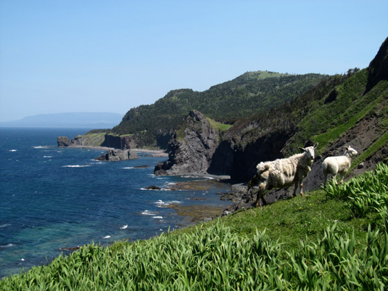
“Who was this guy, and how did a remote mountain in southwestern Newfoundland ever end up with his name? Wikipedia tells me that Pope Gregory I, commonly known as Saint Gregory the Great, was the head of the Catholic Church from 3 September 590 to his death in 604. No amount of googling will answer the second question. This mountain is located just inland from the Gulf of St Lawrence, and is about 18 kilometers, as the crow flies, southwest of the town of Trout River. It resides on a high plateau, in terrain seldom visited by humans. The rain falling on its broad gentle shoulders, that doesn’t drain directly into the Gulf to the west, cascades through craggy barren canyons into the Lower Crabb Brook to the south, and Gregory River to the East and North. The Gregory at its headwaters flows north, and then as the volume increases, curves to the west around Crow Head (directly northeast of Mt St Gregory), before eventually draining into the Gulf. At this junction of river and ocean lies Chimney Cove, a partially abandoned fishing community accessible only by boat or over a gnarly ATV trail. I had done some exploring in the barrens of the North Arm Mountain plateau, and in places could see across the Gregory River to Mt St Gregory. The view was alluring.

August 4/12: This morning I had driven my Subaru as far as I dared down the rutted road toward Chimney Cove. I wanted to hike to Mt St Gregory as efficiently as possible. My plan was to drop into the Gregory River and hike up to its tributary, Jumbo Brook, and follow that to the highland barrens. From there the summit could be easily attained over the moderately sloped barrens. Leaving the car in the early afternoon, I headed directly toward the Gregory River following a drainage between two hills. Alder brush can often grow as thick and impenetrable as tuckamore, and this was the case for the next two hours as I managed to cover only two cursed kilometers before finally breaking out onto what looked like the broad open expanse of the Gregory River. It was obvious I would have made better time hiking all the way down to near Chimney Cove and back up the river.
My energy quickly revived, and with the majestic mound of Crow Head looming over the river to the south, I hastily charged upstream, hoping to get close to Jumbo Brook before nightfall. Nearly three kilometers later my common sense finally kicked in as it became clear I was not hiking where I had thought I was. Crow Head had prematurely disappeared from view, and the river had quickly become way too small for the many acres of drainage I knew lay ahead. My brisk pace came to parade rest, and I sheepishly pulled out my GPS to see where I had wandered. It was hard to accept I could have been so stupid as to follow a tributary that far without checking my location earlier. Coming out of the alders, I had been very close to the Gregory River and had amateurishly concluded this large tributary was the Gregory without a positive confirmation. It seemed I needed a refresher course in Trekking 101.
Trying my best to regain composure and momentum, I charged back down the brook and before long was on the real Gregory River. For the first time that day I was making good time (in the right direction) hiking up the broad cobblestoned riverbed with a narrowing canyon becoming visible ahead. I made it to the Chimney Cove Pond tributary at dusk, quickly erected my tent on the grassy bank of the fork, and without even thinking of food was instantly consumed by irrepressible sleep.

August 5/12: Heading upstream from the fork the sides quickly closed in and I entered a shallow gorge that, as it turned out, was the only one Gregory River had to offer on this trek. The short sides were vertical in places with knobby faces that engulfed deep round swimming holes. From here to Jumbo Brook the hiking was more challenging than the easy walking of yesterday.

Jumbo Brook was inviting at first, but quickly turned into a series of tight cascades, so I exited left, climbing onto the highlands and soon had my first glimpse of Mt Saint Gregory on the western horizon.

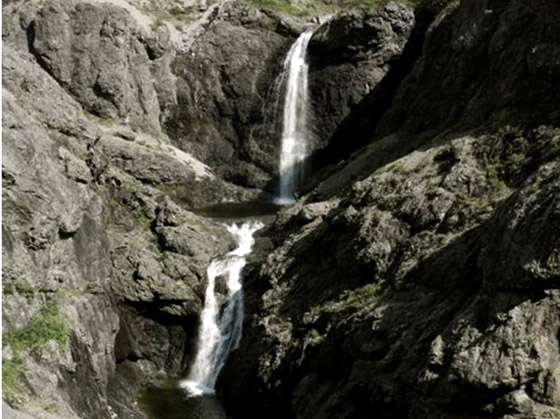
As I traversed the upper grassy plateau, a deep, convoluted canyon emerged to my south, and its seductive appearance began to alter my course. This was a headwater gorge of Lower Crabb Brook, and I had fleeting glimpses of two free-leaping waterfalls, one stacked over the other. My will power prevailed, and I detoured no further into that gorge. The sunny weather I was enjoying was not forecasted to last long, and I was determined to head straight for the top of Gregory before being enveloped in fog. I was grateful for the full view as I summited. Two large cairns, which look like they were erected many years ago mark the highest points of this whaleback mound. Looking south you can see the Bay Of Islands, and Blow-Me-Down Mountains on the horizon,

and looking north over Crow Head, the reddish-brown peridotite Tablelands are clearly visible.

Hiking north from here I was rewarded with overhead views of the picturesque, green pastured settlement of Chimney Cove.

I dropped off the highlands by hiking down The Feeder to Gregory River. Not too surprisingly I didn’t try the alder shortcut this time, hiking down the Gregory to the ATV trail, and was back at my car just before dark.
The Sequel
August 13/13: The indelible image of the double “Stacked Falls” I had glimpsed last year in the gorge of Lower Crabb Brook would not leave me in peace. I had set a goal to further explore this area, and left early this morning heading down the furrowed ATV trail to Chimney Cove. A cabin-owner there pointed across the lush green pastures to a trail disappearing into the woods, which he said was my best route up onto the Gregory Highlands. It was the most miserable overgrown, muddy trail I have ever tried to follow. I quickly abandoned it, and began bushwhacking a beeline for the white colored highlands on my topo map. Once on the highlands, I skirted the cloud-enshrouded Mt St Gregory on the east side and dropped into a large barren canyon just west of Stacked Falls.

The going was challenging in this steep-walled riverbed until I descended into the gently sloping valley of Lower Crabb Brook. As I lost elevation, I suddenly began seeing good-sized brook trout darting everywhere. This pristine, fertile valley is covered with acres of ferns, is laced with moose trails, and abounds with exemplary trout pools. Roasted trout on a forked stick over an open fire was all the nourishment I needed that evening.
August 14/13: I awoke early, anxious to penetrate the formidable Stacked Falls Gorge. For the past year I had been wondering what it would be like. As I left the main valley heading into the gorge, the brook began zigzagging through narrow slots, and cascading over short waterfalls.

After one of these cascades, the darting trout were seen no more. The waterway was so tight in places with vertical sides that I barely managed to slip through. As I inched my way forward the canyon slowly opened up, and became mostly barren letting in some of the early morning sun. Suddenly, rounding a bend, there was the fully exposed, pounding water of Stacked Falls. After having seen only cropped glimpses of these falls, this abrupt, naked frontal left me arrested.

After a cold dunk in the lower landing pool, I earnestly scanned the canyon walls, searching for a way out, with no success. I was not eager to retrace my route back, but another option didn’t show itself until I retreated back around the bend and latched onto a possible way up on the west wall. Standing in the brook I could only see about a third of the way up the wall, but that looked doable by linking some grassy ledges. One of the links over loose scree proved challenging, but I was relieved the upper two-thirds were relatively easy, traversing over a modestly pitched talus slope. The canyon top provided stellar views of the falls below, and from there, a quick detour down to the upper falls left me with an overall vision of this captivating gorge.

My exit involved relatively easy hiking across the big rounded mound called Crow Head.

From there I headed out The Feeder back to civilization.”
Lew Coty


