In June 2010, the International Appalachian Trail welcomed Scotland's West Highland Way as the first IAT trail outside of North America. In September 2013, the WHW will host the first IAT Annual General Meeting in Western Europe.
The well-known and scenic trail was approved for development in 1974 and opened on October 6, 1980 as the first official long distance footpath in Scotland. It is managed by the West Highland Way Management Group (WHWMG) consisting of the West Dunbartonshire Council, Stirling Council, Argyll & Bute Council, Highland Council, and Loch Lomond and The Trossachs National Park, site of the 2013 IAT AGM.
The 154km (96mile) south to north linear trail echoes with stories of the past,
including Rob Roy MacGregor, as it follows historic old drove and coaching roads,
disused railway lines, and military roads built to
help control the Jacobite Clans.
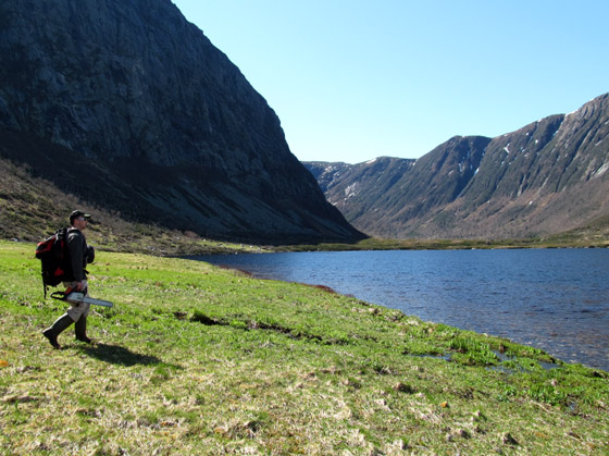
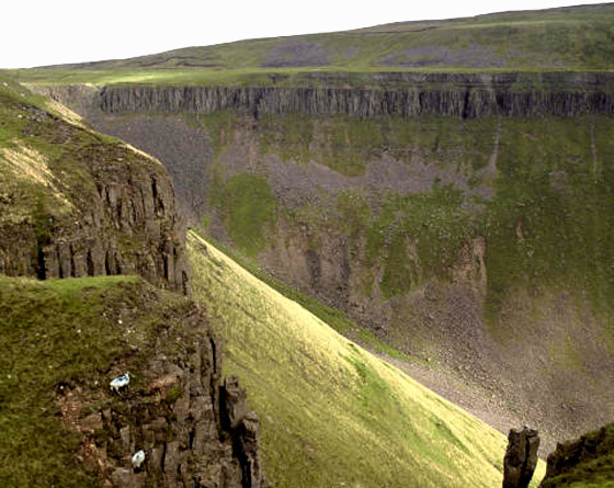
It starts at Milngavie, passes through Mugdock Country Park, follows the shores of Loch Lomond while passing Ben Lomond, passes through Glen Falloch and Strathfillan, crosses Rannoch Moor, past Buachaille Etive Mor to the head of Glencoe, climbes the Devil’s Staircase, descends to sea level to cross the River Leven at the head of Loch Leven, before entering Lairigmor and Glen Nevis and finishing at Gordon Square in Fort William near the base of Ben Nevis, which at 1,344 meters (4,409 ft) is the highest mountain in the British Isles.
Glen Nevis
The terrain ranges from lowland moors, dense woodland and rolling…
In March 2011, the UK's Cleveland Way National Trail joined the IAT as a member of the Coast Alive group of North Sea trails. Its 109 miles (176 kms) of ever-changing and beautiful landscapes was opened in 1969, as the second National Trail in England and Wales.
The route follows a horseshoe line of great variety around much of the beautiful North York Moors National Park. Starting from the attractive market town of Helmsley, The Cleveland Way heads across the inspirational, and sometimes vibrant heather Moorland of the North York Moors, before reaching the coast at Saltburn. From here it’s a visual feast along the dramatic North Yorkshire coastline to Filey, passing old fishing villages and lively coastal towns.
Along the way there is a wealth of history and heritage to enjoy. Helmsley Castle, Rievaulx Abbey, Mount Grace Priory, Gisborough Priory, Whitby Abbey and Scarborough Castle to name just a few special sites.
Scarborough Castle, Scarborough, North Yorkshire
The combination of moors, dales, woodland and coast that make up the Cleveland Way give it a unique character. These are special landscapes. So much so that most of the route falls within the North York Moors National Park and along the North Yorkshire and Cleveland Heritage coasts.
Coastline Above Maw Wyke Hole
Moorland dominates the western part of the Cleveland Way. The North York Moors itself contains the…
In June 2013, IAT Europe Vice Chair Magne Haugseng traveled to Greenland where he met with IAT Greenland representatives, including Birgitte Pedersen of Blue Ice Explorer in Narsarsuaq, South Greenland. (See also Greenland's IAT Crosses Erik The Red Land .)
"Our meetings in Greenland were good. Really useful. But there are concerns around the future of Narsarsuaq airport. If it closes or is downgraded to a helicopter landing pad, the place will probably die. The Norwegians are starting to look at the viability of seeking UNESCO status for the Brattahlid Viking site across the fjord. The Vinland site at L’Anse aux Meadows, Newfoundland is listed, which should help.
Viking Site at Brattahlid
Jacky Simoud and Birgitte are going from strength to strength at Blue Ice. They seem to be the prime movers in Narsarsuaq with their tours, boats, café and hostel, and the coffee at the café is as good as ever! A great team and a real asset to the IAT in Greenland. I left them with some of the smaller vinyl IAT stickers, similar to those we have issued in Norway.
Blue Ice's Birgitte Pedersen holding an IAT Greenland Blaze
The walking around Narsarsuaq is great. There is a good walk up to the glacier, and another day or two easily taken up with a trip over from the famous Viking Site at Brattalid (Qassiarsuk) to the Sermilik fjord to see all the ice floating past. From…
On Monday June 3, IAT Maine board members Dick Anderson and Thomas Urquhart had the pleasure of meeting John Judge, the new President of the Appalachian Mountain Club (AMC) at a gathering at the home of IAT member Elizabeth Ehrenfeld in Falmouth, Maine.
L-R, IAT Founder Dick Anderson, AMC President John Judge, and IAT Maine Board Member Thomas Urquhart.
They had several opportunities to bring John up-to-date on the status of the IAT in both North America and Europe, and also learned more about the many outdoor programs organized and managed by the AMC. It was a nice, social evening that allowed Thomas and Dick to make a connection to the leader of one of the most influential and effective outdoor conservation and recreations organizations in North America.
The AMC was founded in 1876 and is the oldest outdoor and recreation organization in the United States. AMC has 100,000 members, 16,000 volunteers, 450 full-time and seasonal staff, and 12 chapters from Maine to Washington, D. C. AMC also produces an award-winning magazine, AMC OUTDOORS, which published a feature story about the IAT in 2007.
To learn about the AMC and their many wonderful programs and activities, visit www.outdoors.org.

On the evening of May 15, 2013, IAT Chairperson Paul Wylezol and IATNL executive member Delano Pittman set off in an open boat across chilly and windswept Parsons Pond on their way to Western Brook Gulch to continue work on the Devil’s Bite Trail. Rising early the next day, they hiked a round trip of 13 kms (8 miles) to reach the worksite at the inside valley, where the trail climbs a scree field to the only exit out of the gulch.
Download the IAT Quebec April 2013 Newsletter in Francais or English.
Check out the news from IAT Quebec in their April 2013 Newsletter! Highlights include trail developments in 2012, plans for 2013, and messages from IAT Quebec officials.
Download the IAT Quebec April 2013 Newsletter in English or Francais.
This second installment of IAT Natural Heritage is by Beyond Ktaadn's Mike Jones (IAT North America Alpine Ecologist), Liz Willey, and Marilyn Anions and is excerpted and adapted from their new Eastern Alpine Guide, with photos by IATNL.
Newfoundland's Bay of Islands Ophiolites
It’s only about two hours from the fogbound ferry terminal at Port-aux-Basques up the Gulf of St. Lawrence coast, to the logging roads that lead into the mountains surrounding the Bay of Islands. There are four mountain ranges in all: broad, ocean-front mesas with enormous alpine tablelands, encompassing little-known but spectacular ranges known as the Lewis Hills, Blow Me Down Mountain, North Arm Hills, and Tablelands.
The island of Newfoundland rises to its highest point near the center of the Lewis Hills, at a windswept and lonely dome known as The Cabox. The Cabox’s westerly vantage takes in the Gulf of St. Lawrence from the Port au Port Peninsula to the North Arm Hills. Several vantage points along the western rim of the Lewis Hills tableland peer down vertically to the ocean, 600 meters (2,000 feet) below. These vistas are vivid testament that in Newfoundland, spectacular mountain scenery can exist at elevations under 1000 meters.
North Arm Hills from Cape Blow Me Down
The four mountain ranges can be divided into two pairs at the Bay of Islands, itself one of the most identifiable features on the western coastline of Newfoundland. The Lewis Hills and Blow Me Down Mountain form the southern bloc (roughly, the area southwest of the city of…

In April 2013, Britain’s first National Trail – the Pennine Way – joined the IAT. The 268-mile (429-km) path follows the top of the Pennine Mountains along the rugged backbone of north-central England, from the Peak District National Park through the Yorkshire Dales and over Hadrian’s Wall to the Cheviots Hills on the border with Scotland. It is amongst the finest upland walking in England.
In April 2013, Britain's first National Trail - the Pennine Way - joined the IAT. The 268-mile (429-km) path follows the top of the Pennine Mountains along the rugged backbone of north-central England, from the Peak District National Park through the Yorkshire Dales and over Hadrian's Wall to the Cheviots Hills on the border with Scotland. It is amongst the finest upland walking in England.
The Peninne Way National Trail is a grand traverse up the center of England, with 17% within the Peak Districk National Park, 20% in the Yorkshire Dales National Park, and 24% within the Northumberland National Park. (Total 61% designated.) Highlights include Kinder Scout, Stoodley Pike, Top Withins, Malham Cove, Pen-y-ghent, Tan Hill, High Force, Cauldron Snout, High Cup Nick, Cross Fell, Hadrians Wall, and The Cheviot.
Hadrian's Wall Path
The trail takes approximately 16 days to complete, from the start at Nags Head pub in Edale to the finish at the Border Inn in Kirk Yetholm. Its highest elevation is 893 meters (2,947 feet) at Cross Fell in Cumbria, the highest point in England outside of the Lake District.
Cross Fell, which at 893m (2,947ft) is England's Highest Peak outside of the Lake District
Pennine Highlights
Pennine Hightlights is a 5-day walk along a section of the Pennine Way that takes in some of the spectacular landscape of the trail.
Day 1: Hawes to Keld (20km/12.5 miles)
Hawes is the capital of the little Kingdom of Wensleydale, a friendly busy market town.
Hawes…
In late March 2013, IAT Maine board member Thomas Urquhart set off on the South Downs Way to again walk the hills he roamed as a young lad growing up in the south of England. Join him and his wife and sister as he recounts the sheep and grazing bunnies on Easter Sunday morn.
"Let’s be clear. There is very little “Appalachian” about England’s South Downs Way. It is made of chalk and flint laid down during the Cretaceous period, anything from 100 to 200 million years after the cataclysmic orogeny that threw up what we know as the Appalachians.
On the other hand, the South Downs Way taught me just about everything I know about nature, not least the pleasures of an extended walk punctuated by a thankful pint at a pub. So when the powers-that-be included their 90-plus mile footpath as an official part of the International Appalachian Trail in order to connect Western Europe's "Appalachian Mountains," I was happy to reconcile geological punctilio with my life-long relationship with the hills that capture the gentle essence of the Sussex Weald.
Last Easter morning, joined by my wife and sister, I took to the well-loved path up Amberley Mount. When they were being considered for national park status, there was some question as to whether this end of the South Downs would be included. Intensive agriculture has taken over a lot of the land where sheep and rabbits used to make the grass velvet-firm, and parts of…