During summer 2017, the International Appalachian Trail Newfoundland & Labrador in conjunction with Cabox Aspiring Geopark is commemorating the 250th Anniversary of British navigator, surveyor, cartographer and explorer James Cook’s survey of Western Newfoundland, his fifth and final year of Newfoundland surveys and tenth and final year in Eastern Canada. Commemorations include three new indoor exhibits and the re-designation of two trails on the south side of the Bay of Islands and began on June 21 with an official launch at the Corner Brook Museum and Archives, which has a permanent exhibit dedicated to Cook.
Copy of James Cook’s draft map of Western Newfoundland at the Corner Brook Museum and Archives (click to enlarge)
Memorial University of Newfoundland (Grenfell Campus) History Professor Olaf Janzen discussed Cook’s time in Newfoundland, including surveys of the Strait of Belle Isle (1763-64), South Coast (1765-66) and West Coast (1767).

Memorial University Professor Olaf Janzen discussing James Cook at the Cook 250 Launch
These were undertaken after the Seven Year’s War, when Cook met and learned surveying from British Navy engineer Samuel Holland, then helped navigate the British fleet up the St Lawrence River to defeat the French on the Plains of Abraham.

Death of General Wolfe [on the Plains of Abraham] by Benjamin West, 1770
After helping to recapture St. John’s from the French during the last battle of the war in North America, Newfoundland Governor Thomas Graves successfully lobbied the British Admiralty to appoint Cook as surveyor of Newfoundland, where his unprecedented surveys while commanding the schooner Grenville and his description of a solar eclipse on the south coast near Burgeo led the British Admiralty and Royal Society to select Cook to lead an expedition to the South Pacific in 1768 to witness the transit of Venus and search for the fabled southern continent.
Cook Chart of the West Coast of Newfoundland , published 1768 (click to enlarge)
James Cook 250 exhibits at the Woods Island Resettlement House and Historic Center in Benoit’s Cove, Community Museum in Gillams, and Gros Morne National Park’s Discovery Center in Woody Point tell the story of Cook with maps and engravings from his Newfoundland surveys and Pacific voyages.

Two outdoor exhibits are planned for new trail designations at York Harbour, where the Copper Mine to Cape Trail was re-designated as the Cape Blow Me Down Trail (Cook’s name for the mountains) on July 1 Canada Day, when 250 years ago Cook was surveying the Bay of Islands,

L-R Kevin Noseworthy (IATNL), Allan Shepherd (OBIEC), Mary-Lou Shepherd (OBIEC), George Perry (OBIEC), Arne Helgeland (IATNL), and Paul Wylezol (IATNL) at the new trailhead sign for the Cape Blow Me Down Trail
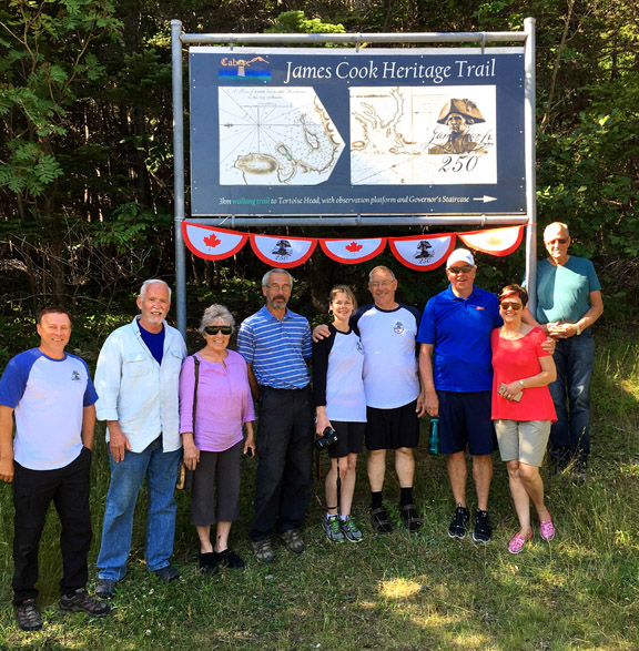
and at Blow Me Down Provincial Park in Lark Harbour where, with the help of David Startzell, long-time Executive Director of the Appalachian Trail Conservancy and his wife Judy (former editor of AT Journeys magazine), the trail to Tortoise Head (aka Lark Harbour Head) was designated as the James Cook Heritage Trail.

L-R Paul Wylezol (IAT), David and Judy Startzell (ATC), Kevin Noseworthy (IATNL), Mary-Lou and Allan Shepherd (OBIEC), John and Sharon Parsons (OBIEC), and Arne Helgeland (IATNL) at the new trailhead sign for the James Cook Heritage Trail on July 26, 2017
In addition to exhibits and trails, James Cook 250 is also being marked with a new beer by the Western Newfoundland Brewing Company, which is brewing a James Cook Spruce Beer to commemorate Cook’s practise of making the beer – with a healthy dose of vitamin C – to help prevent scurvy among his crew.

Jim Macdonald pours a fresh glass of spruce beer at the Western Newfoundland Brewing Company
So when hiking IATNL trails in Western Newfoundland this year, reflect on the amazing feat of James Cook
….. and consider that a hiker stumbling over his feet may be due to the beer and not the condition of the trail!
For more on James Cook in Newfoundland and the Pacific, go to jamescook250.org


