July 30, 2010 I made a one-day excursion into the terrain south of the upper end of Trout River Pond to see Overfall up close. This majestic waterfall is visible for many miles from its east side and is often used as a reference like the North Star for hikers in that area. At that time the IAT had not yet completed a trail there from Trout River Pond; the closest access I knew of was from a forestry road coming out of Glenburnie. The reward of seeing this roaring drop of water up close made the arduous hike through lots of tuckamore worth it. I found a much more pleasing route on my return going around the west side of Overfall Hill and descending through a beautiful grassy valley. Such was the motivation to come back for more exploration in this area.

August 14, 2011 It was through this valley I started out in the early morning of a splendid sunny day and soon reached the alpine barrens above, where the eastern view opened up. I was headed south across the North Arm Mountains which are really just large rounded mounds bubbling out of this upper plateau. The hiking here is relatively flat over alpine vegetation including lots of sphagnum moss, Labrador tea and cloudberries which Michael Longley describes as bog amber, snow-line tidbits, sweetened slowly by the cold. They are one of my favorite trail snacks.
By noon I approached the North Arm of the Bay of Islands. I was walking over large masses of black lichen clinging to the brown peridotite rock and skirting the shores of small highland lakes often lined with clusters of cotton grass.

As the North Arm became visible below I was soon confronted with an ominous looking canyon that ended in a pronounced delta at the shore of the bay. This canyon was steep, jagged and v-shaped. Both the canyon and delta appeared to have been formed by rushing water rather than a glacier, though there wasn’t a trace of water in it despite the abundant recent rains, nor was there any real watershed above to supply water during heavy storms.
Heading southwest from there I followed a barren ridge that yielded views of the Bay of Islands and the Blow-Me-Down Mountains in the distance. Looking west, the relaxed sunshine of the morning was giving way to thunderheads. I turned north heading towards Liverpool Brook, hoping for less exposed surroundings as black skies and occasional flickers of lightening were catching my attention on the left. As I approached Liverpool Brook I quickly hunkered down as I was soon inundated with hard rain and lightning flashes.

The rain finally subsided late in the afternoon and I was surrounded by a roving mist that gave me glimpses of the canyon I was entering. On my right was a free leaping waterfall on a tributary stream. Its landing splash blended seamlessly with the fog. Ahead was a narrow grassy ledge that descended to the base of the canyon like a stairway. Upstream from this emerging at intervals through the misty shroud, were several more waterfalls. I spent the night on that grassy ledge hoping for a clear view up the canyon next morning.
August 15, 2011 Much to my dismay that view never evolved as daybreak revealed a dense fog. Blindly I descended the ledge hoping to cross the brook at that location but the bank on the west side was steep and gnarly. I was not inclined to risk ascending slippery ledge, especially being alone. I continued up the east side of the brook crossing above a waterfall on another tributary that fell through the fog to the brook below, and easily crossed Liverpool Brook about a kilometer to the north.
The hiking was fairly easy all the way to Crabb Brook which I crossed in its upper waters where the canyon was shallower. Looking upstream in the distance was an intriguing free leaping waterfall on one of the headwater tributaries. Up close revealed a graceful, delicate falls that would probably sway in a high wind. Unlike most of the big muscular waterfalls I have encountered in Newfoundland this one had a definite feminine quality and I named it Sue.

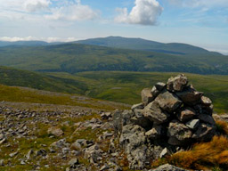
It had turned into a stellar sunny day and I was looking for a good view west. Not far northwest of Sue I came to an exposed knoll with a large cairn on top and a spectacular 360 view. Looking northeast I could see the peridotite barrens of the tablelands over Trout River Pond, looking north I could look right down into Gregory River Canyon, to the west was Mount ST Gregory (I must climb that next year), and to the southeast were the North Arm Mountains I had come from.
One kilometer east I crossed another exposed knoll where I had a good view of Overfall Hill on the horizon and my route back. The walking was mostly over grassy wetlands, often following moose trails (some double lane), to Sandy Pond where I made a side trip to the top of Overfall. Creeping to the edge of the ledge, which hangs over the top of this waterfall, I am always overwhelmed by the sight. There is virtually no transition between the placid blue lake above and the thunderous plunge of white water below. The lake nonchalantly spills its guts over a 1000ft cliff.

It was turning to late afternoon when I headed back to Grassy Valley but fortunately I knew the route well. My final hour was aided by headlamp.
Lew Coty


